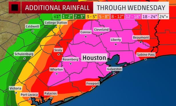
Rainfall amount chart

HOUSTON—The storm is still ongoing in the metro area and may continue for several days. The US Army Corps of Engineers announced its plans on Sunday to begin releasing water into Buffalo Bayou from the Barker and Addicks reservoirs on the western outskirts. The engineers said water was to be very slowly released from the dams Monday to prevent uncontrollable flooding in downtown and the Houston Ship Channel. The water contained by the dams was described as “unparalleled in the dams' history.” The waters are rising by roughly 4 inches every hour.

Residents are advised to only call 911 with immediate needs for medical attention or evacuation assistance. If the lines are jammed on 911 on the first try, the Federal Emergency Management Agency/FEMA advises callers to continue dialing.

Another option is to place a call to one of five numbers for the Houston Command Center of the US Coast Guard. The numbers are 281-464-4851, 281-464-4852, 281-464-4853, 281-464-4854 and 282-464-4855.

“CBRE's property managers in Houston are working diligently to ensure onsite staff and personnel are safe. We are keeping a constant eye on how Houston's properties are faring,” Mark Nicholson, senior managing director, CBRE Asset Services in Houston. tells GlobeSt.com. “Because this is an ongoing situation, current conditions do not allow for full property assessments due to lack of access.”

In addition, Camden Property Trust announced yesterday that preliminary reports indicate only minor damage to the company's apartment communities located in Houston and Corpus Christi, TX and all communities are currently operational.

“We are focused on taking care of our residents and employees, and then we will assist in helping our neighbors who have been severely impacted,” said Keith Oden, Camden's president.

Obviously, this is still a dangerous storm, and residents and visitors in areas potentially affected by the severe weather should continue to monitor local radio or TV stations for updated emergency information, advises FEMA.

Property owners should return only when authorities indicate it is safe, but continue to watch out for debris and downed power lines. Walking or driving through flood waters is unsafe. Just 6 inches of moving water can knock down a pedestrian and one foot of fast-moving water can sweep a vehicle away. Also, flood water may be electrically charged from underground or downed power lines and may hide dangerous debris or places where the ground is washed away.

FEMA advises property owners to photograph damage to properties in order to assist in filing an insurance claim. Owners should do what they can to prevent further damage properties with tarps, etc. as insurance may not cover additional damage that occurs after the storm.

A major flood still occurs somewhere in Harris County about every two years, according to the Harris County Flood Control District. Fortunately, since the 1970s, there has been flood insurance to ease the financial impact of flooding. Despite tremendous flood damage reduction projects that have indeed reduced the risk of flooding, more flood insurance funds have been paid here than in any other National Flood Insurance Program/NFIP-participating community.

Everyone living in a participating community of the NFIP can buy flood insurance. Harris County and the incorporated cities within the county are participants in the NFIP. Just because a property is not mapped within the 100-year floodplain does not mean it is free from the potential to flood.

FEMA Flood Insurance Rate Maps/FIRMs show areas subject to flooding from a primary flooding source, typically major rivers, bayous and tributaries, and are meant to help determine the risk of flooding for a property. However, flooding from sources that are not identified on the FIRMs is possible and occurs often in Harris County.

Many properties flood because excess storm water cannot drain into a storm drainage system fast enough to prevent localized ponding from reaching the interior. On a national basis, one-third of the flood loss claims are from property located outside of the mapped 1% (100-year) floodplain, meaning that not all flooding sources are calculated when determining risk.

The NFIP is administered by FEMA and FEMA produces FIRMs, which are based on technical analyses, studies and historical flooding information. FIRMs contain a variety of information, including flood risk information, special flood hazard areas, Base (or 100-year) Flood Elevations, areas subject to inundation by the 1% (100-year) and 0.2% (500-year) floods along primary channels, and common physical features such as streams, highways, roads and railroads. FIRMs can usually be viewed at a local community map repository site, typically, a local planning or engineering office, or by contacting an insurance agent or mortgage company. For a nominal charge, FIRMs can be ordered from FEMA.

Harris County Flood Control District is a special purpose district created by the Texas Legislature in 1937 in response to devastating floods that struck the region in 1929 and 1935. Most of the flooding was in areas developed prior to the current understanding of flood potential and prior to regulations restricting construction in flood-prone areas.

Want to continue reading?
Become a Free ALM Digital Reader.

Once you are an ALM Digital Member, you’ll receive:

  • Breaking commercial real estate news and analysis, on-site and via our newsletters and custom alerts
  • Educational webcasts, white papers, and ebooks from industry thought leaders
  • Critical coverage of the property casualty insurance and financial advisory markets on our other ALM sites, PropertyCasualty360 and ThinkAdvisor
NOT FOR REPRINT

© 2024 ALM Global, LLC, All Rights Reserved. Request academic re-use from www.copyright.com. All other uses, submit a request to [email protected]. For more information visit Asset & Logo Licensing.

Lisa Brown

Lisa Brown is an editor for the south and west regions of GlobeSt.com. She has 25-plus years of real estate experience, with a regional PR role at Grubb & Ellis and a national communications position at MMI. Brown also spent 10 years as executive director at NAIOP San Francisco Bay Area chapter, where she led the organization to achieving its first national award honors and recognition on Capitol Hill. She has written extensively on commercial real estate topics and edited numerous pieces on the subject.

lisabrown

Just another ALM site